Population statistics
Population statistics record the number of people living in the area. This page provides more detailed information on Aberdeenshire’s population from the 2024 estimates provided by NRS, and Scotland's Census 2022.
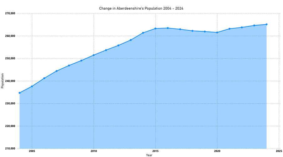
Aberdeenshire total population by year
In 2024, the NRS estimated that Aberdeenshire’s population was 265,080. This was an increase of 470 people (0.2% increase) since 2023. During the same period the population of Aberdeen City increased by 1.1% (from 229,360 to 231,780).
Since the COVID-19 pandemic there has been moderate sustained growth in Aberdeenshire. Between 2016 and 2020 the population of Aberdeenshire had been falling, following a long period of growth.
| Year | Population |
| 2024 | 265,080 |
| 2023 | 264,320 |
| 2022 | 263,750 |
| 2021 | 262,690 |
| 2020 | 260,780 |
| 2019 | 261,210 |
| 2018 | 261,470 |
| 2017 | 261,800 |
| 2016 | 262,190 |
| 2015 | 261,960 |
| 2014 | 260,530 |
| 2013 | 257,770 |
| 2012 | 255,560 |
| 2011 | 253,650 |
| 2010 | 251,430 |
| 2009 | 249,020 |
| 2008 | 246,840 |
| 2007 | 244,390 |
| 2006 | 241,180 |
| 2005 | 237,570 |
| 2004 | 234,690 |
Population of wards and administrative areas 2022
The Census (last undertaken in March 2022) provides the most recent information on the population of each administrative area and electoral ward in Aberdeenshire,
View the population of each:
- Administrative area - in the table below
- Administrative area: broken down by individual wards (PDF 158KB)
| Administrative area | Population |
| Banff and Buchan | 36,773 |
| Buchan | 42,746 |
| Formartine | 42,889 |
| Garioch | 56,676 |
| Kincardine and Mearns | 46,711 |
| Marr | 37,922 |
Population of towns and villages 2022
The following table shows the population of the 6 largest towns in Aberdeenshire, based on 2022 Census results.
| Largest towns | Population |
| Peterhead | 19,791 |
| Inverurie | 15,106 |
| Fraserburgh | 12,921 |
| Westhill | 11,750 |
| Stonehaven | 11,177 |
| Ellon | 10,126 |
You can also view figures for Aberdeenshire towns and villages with a population greater than 500 people (PDF 169KB).
Population and household estimates and projections
View summaries of the most recent population and household projections for Aberdeenshire:
- 2022-based population projections for Aberdeenshire (PDF 324KB)
- 2022-based household projections for Aberdeenshire (PDF 292KB)
You can also view up to date figures for Aberdeenshire household and dwellings estimate 2024 (PDF 214KB).
Find out more details about population, migration and households for Aberdeenshire and Scotland on the National Records of Scotland (NRS) website.